
.png)
.png)

Whether you're running, cycling, commuting, or simply at home, AirTrack provides personalised insights into how the air around you affects your health and performance. By tracking real-time pollution levels 24/7 indoors and outdoors we help you make healthier daily choices, optimise your workouts, and protect your long-term health.


.svg)

Integrate AirTrack for free and join our Strava Club.
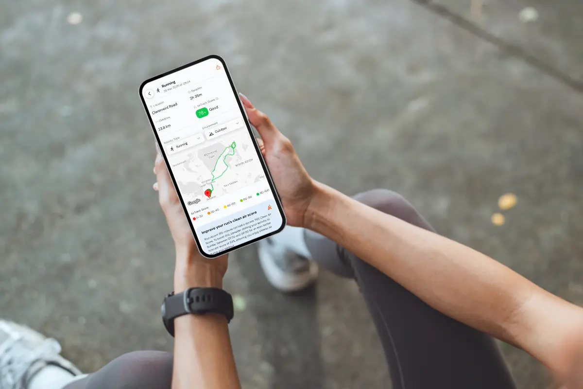

AirTrack runs in the background, automatically tracking your day across commuting, work, exercise and rest, indoors and outdoors.
Discover better routes and the best times of day to be active based on real-time air quality.
Get tailored, coach-like insights that turn your exposure data into simple, actionable steps.
Plan ahead with forecasts covering air quality and grass, tree, and weed pollen levels helping you pick the best times to be active and keep hay fever and allergies in check.
Sign up for free above to create an AirTrack account. You can choose whether to link to Strava, Apple Health, or Google Health Connect. After that, go about your day as normal.
Log your workouts so you can see your activity and basic exposure, and with Premium, track your entire day with real-time, location-specific air quality and pollen insights.
Access essential air quality data for free, or unlock Premium features for more in-depth analysis and pollen data.
£0.00/month
Get essential air quality insights for your activities.

Apple/Google Health sync
Strava sync
Sharing an Activity
Live Air Quality Readings
Manual Activity Tracking
Same-Day Air Quality Forecast
Join Leaderboards
Post Activity Notifications
Unlock 24/7 air quality tracking for deeper insights.

Effortless Always-On Tracking
4-Day Air Forecasts
Personal AirCoach Guidance
Cleaner Route and Timing Suggestions
Create Leaderboards
5 Day Detailed Pollen Forecast (Grass, Tree, Weed)
5 Pollutant Tracking (PM2.5, PM10, NO2, O3, SO2)
App Integrations (Strava, Apple Health, Google Health Connect)
Personalised Strava Activity Feed
Daily and Post Activity Notifications
AirTrack helps you understand how air quality impacts your health and performance. Knowing your exposure to pollutants like PM2.5 (fine particulate matter) and NO2 (nitrogen dioxide) will help you take proactive measures to reduce risk. AirTrack uses high-resolution data that changes over time and location, so be sure to check in regularly for updates from the air map.
Learn more
A major health risk, linked to heart disease and poor athletic performance. Even short-term exposure can affect your speed and endurance. The WHO recommends a daily limit of 15 micrograms per cubic metre.

Causes airway inflammation and worsens conditions like asthma. Long-term exposure increases the risk of lung diseases. The WHO recommends a daily limit of 25 micrograms per cubic metre.
Contact support@airawarelabs.com if you have any problems,
and we'll get you patched up.
AirTrack is a mobile app that helps you understand and reduce the air pollution you’re actually exposed to throughout your day. With the new 24/7 personalised tracking feature, it combines high-resolution air quality data with your location, routes, and activities to estimate your cumulative exposure: whether you’re commuting, exercising, working, or at home. AirTrack provides personalised insights and actionable recommendations to help you make healthier choices, all without any additional hardware.

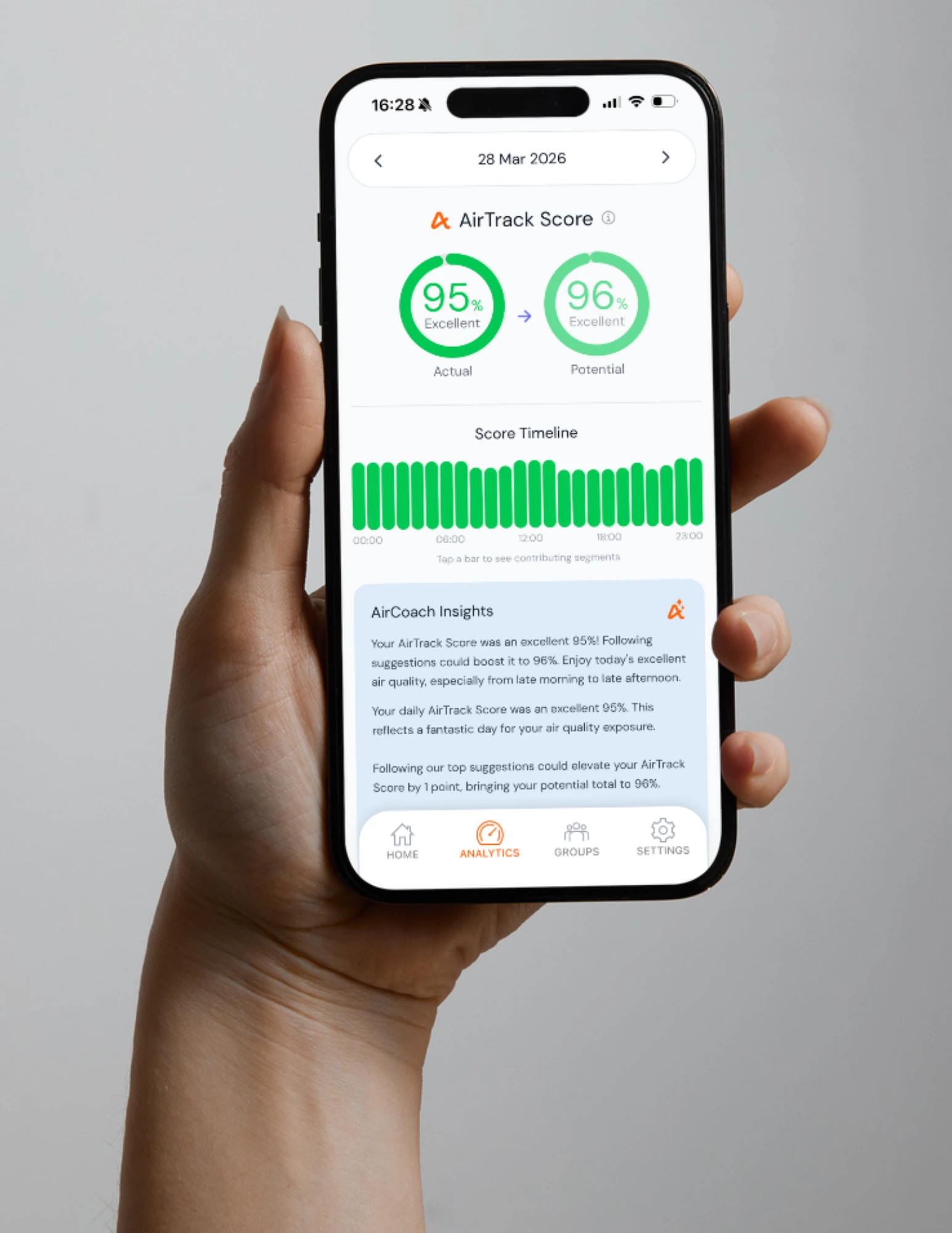
AirTrack estimates the air you actually breathe throughout your day, not just the pollution at a single location.
It combines:
AirTrack then calculates your personal exposure by combining:
This produces a time-weighted exposure score, giving you a clearer picture of your real-world air pollution exposure. Accuracy is validated against monitoring stations and tested using standard cross-validation methods.
Read this document to understand more about how AirTrack works including how we get the data and how the AirTrack Score is calculated.
AirTrack helps you understand and reduce the air pollution you actually breathe. AirTrack:
Supports healthier decisions over time, helping you build habits that reduce long-term health risks and improve performance
Yes. We offer three tiers:
Quick-start: Get instant access to live air quality at your location, with no sign-up required.
Free Plan: Includes:
Premium Plan: (£6.99/month or £49.99/year, incl. VAT)
Includes everything in Free, plus:
AirTrack is available for download on:
For existing AirTrack users, Premium subscriptions can be purchased in app. Premium subscriptions can also be purchased through employee wellbeing platforms such as Heka and Healthkey. For more information on how billing works when you cancel, please see our Terms of Use.
No, you can use AirTrack without a Strava account.
If you do use Strava, Apple Health, or Google Health ConnectFit, you can connect them in Settings to sync your activities seamlessly. You can disconnect at any time.
We also have a Strava Club if you’d like to join our growing community and compare exposure insights with others.
View this video with more detail about synching your accounts!
No, AirTrack is designed to be efficient and minimise battery and data usage.
Like most apps that use GPS and background activity tracking, there may be a moderate impact on battery life, but you can adjust location accuracy settings on your device to balance battery usage and tracking precision. If you experience any issues, contact us at support@airawarelabs.com
AirTrack provides real-time air quality data globally through Google’s Air Quality API and other data sources. We operate in the following countries:
Albania, American Samoa, Andorra, Argentina, Armenia, Australia, Austria, Azerbaijan, Bahamas, Bahrain, Bangladesh, Belarus, Belgium, Bosnia & Herzegovina, Brazil, Brunei, Bulgaria, Canada, Chile, China, Costa Rica, Croatia, Cyprus, Czechia, Denmark, Ecuador, Egypt, Estonia, Ethiopia, Finland, France, Georgia, Germany, Gibraltar, Greece, Guam, Guernsey, Hong Kong, Hungary, India, Indonesia, Ireland, Israel, Italy, Japan, Jersey, Jordan, Kenya, Kuwait, Latvia, Liechtenstein, Lithuania, Luxembourg, Malaysia, Malta, Mauritius, Mexico, Moldova, Monaco, Mongolia, Montenegro, Morocco, Nepal, Netherlands, New Zealand, North Macedonia, Norway, Pakistan, Peru, Philippines, Poland, Portugal, Puerto Rico, Qatar, Réunion, Romania, Russia, Saudi Arabia, Serbia, Singapore, Slovakia, Slovenia, South Africa, South Korea, Spain, Sri Lanka, Sweden, Switzerland, Taiwan, Thailand, Turkey, Uganda, Ukraine, United Arab Emirates, United Kingdom, United States, U.S. Virgin Islands, Vatican City, Venezuela, Vietnam.
And we provide real-time and forecast pollen data in more than 60 countries, powered by the Google Pollen API and additional data sources. Coverage and resolution may vary by location.
Andorra, Albania, Armenia, Argentina, Austria, Australia, Bosnia & Herzegovina, Belgium, Bulgaria, Brazil, Belarus, Canada, Switzerland, Chile, China, Cyprus, Czechia, Germany, Denmark, Estonia, Egypt, Spain, Ethiopia, Finland, France, United Kingdom, Georgia, Gibraltar, Greece, Hong Kong, Croatia, Hungary, Ireland, Israel, Italy, Jordan, Japan, South Korea, Liechtenstein, Lithuania, Luxembourg, Latvia, Moldova, Montenegro, North Macedonia, Mongolia, Malta, Mexico, Netherlands, Norway, Nepal, New Zealand, Pakistan, Poland, Portugal, Romania, Serbia, Russia, Saudi Arabia, Sweden, Slovenia, Slovakia, Turkey, Ukraine, United States, South Africa.
Yes, AirTrack is available for organisations through our enterprise solutions.
We offer:
We also provide discounted access to charities for events.
AirTrack collects the data needed to estimate your personal air pollution exposure, including:
This data is used to provide personalised insights and the AirTrack Score within the app.
You are always in control - you can manage permissions and connected apps in your device or app settings.
We may use anonymised and aggregated data to improve our models and for research purposes.
Please see our Privacy Policy for full details.
AirTrack is designed with privacy and security in mind.
If your account is inactive for 12 months, we will contact you to confirm whether you wish to continue using AirTrack. If there is no response, your account and associated data will be deleted after a further 1 month.
For more details, please see our Privacy Policy.
When you connect AirTrack to Strava, we need to access certain fields to be able to work properly.
View data about your public profile
This permission is required to connect AirTrack to Strava. Without this, AirTrack will not be able to connect to your Strava activities. However, you can still use the AirTrack app independently
View data about your activities
This permission is required to work out where and when the activity took place, to calculate air quality information. Without this, AirTrack will not be able to calculate air quality information for your Strava activities. However, you can still use the AirTrack app independently
View data about your private activities
This permission allows AirTrack to calculate air quality information for private activities. You can deselect this option, but we can't calculate air quality information for private activities. Public activities will be processed
Upload your activities from Air Aware Labs to Strava
This permission is required for AirTrack to update the description box with air quality information. We can't update your Strava activity with air quality information without this permission
If you wish to revoke access, go to the settings page in Strava and scroll down to Air Aware Labs, and click Revoke Access. Alternatively, you can disconnect from Strava under Settings in the AirTrack app. This mean you will need to record activities within AirTrack app in order to get your air quality data.
If you have signed up to Strava integration and record your routes on Strava, we deliver air quality information to the description box in your Strava feed.
You can also put other text in the description box. We take whatever is in that box and append air quality data information when the activity is processed. You can add additional text to the description box for each activity, whether to include more context, specify conditions, or note particular observations.
There are no clashes with other apps such as Bandok.
If you only want us to access public activities, please untick "View data about your private activities" when you connect your account, we only receive information about your public activities and will only annotate those ones - we can't view or access your private activities.
On the other hand, if you do want air quality data in your private activities, please tick "View data about your private activities" when you connect your account.
From April 2026, Premium users have the option of changing the level of detail in their Strava feeds.
Many air quality services use a single Air Quality Index (AQI), which combines pollutants like nitrogen dioxide, particulate matter, and ozone into one number. While AQI is useful as a general indicator, it has limitations:
Instead, AirTrack focuses on personal exposure. For Premium users, we provide an AirTrack Score that gives a more meaningful, personalised view of your exposure - and helps you make practical decisions to reduce it.
Research shows that air pollution can reduce athletic performance. AirTrack helps you identify cleaner routes and optimise workout times to improve your performance. Check our Articles and Knowledge page for the latest scientific research.
We do not aim to discourage outdoor activity - quite the opposite! AirTrack is designed to empower you with information, not scare you. It provides realistic recommendations to help you reduce pollution exposure without compromising on fitness and activity.
Furthermore, AirTrack can help individuals with respiratory issues or heart conditions avoid high-pollution areas and suggest cleaner routes to improve health outcomes. We are working on ways to modify sensitivity for especially vulnerable groups.
Read this document to understand more about how AirTrack works including how we get the data and how the AirTrack Score is calculated.
AirTrack’s Cleaner Route Optimiser helps you find routes with lower air pollution exposure. It works by:
In many cases, a slightly longer route can result in meaningfully lower exposure. You can optimise your routes in the app and explore alternative options based on your journey.
This feature is available for Premium users.
We’re continuously improving this feature and welcome feedback via the in-app 👍/👎 tool.
Just send them the link https://airawarelabs.com/airtrack and ask them to sign up! And if they follow you on Strava and see the data on your feed, they can sign up directly. We’ve also added some sharing features in the AirTrack app - check them out! You can also ask your friends to scan this QR code with their phone camera!
If you are a Premium user, you can create Leaderboards to involve your friends. If you are a Free user, you can join Leaderboards.

Leaderboards let you compare your AirTrack Score with friends, clubs, or other users.
They’re designed to make reducing air pollution exposure more engaging - whether you’re tracking individually or as part of a group. You can join leaderboards for free and see how your exposure compares over time. Premium users can create leaderboards.
Stay in the loop by following us on social media and signing up for email updates::
To receive the latest news, feature releases, and updates directly to your inbox, make sure your email preferences are up to date in the app settings
Our AirTrack mobile app provides a more streamlined and personalised experience. We have now decommissioned the web dashboard including using this for Stripe payments. Download the AirTrack app to continue accessing your personal air quality insights and to benefit from new features that will only be available on the mobile platform. All payments should now be handled via the app.
We’d love to hear from you! Send your feedback through the app or email us at hello@airawarelabs.com.
If you have any problems creating an account or signing in, please email us at support@airawarelabs.com
If you have reset your password but haven't received an email, please check your spam folder for an email from support@airawarelabs.com
If you would like to delete your account and data, please go to the Settings page of the AirTrack mobile app, scroll to the bottom and press Delete Account. Your account and all personal information and data will be deleted. If you have any problems or questions about account deletion, please email us at support@airawarelabs.com and we'll get right on it. After a period of 12 months of inactivity we consider you to be no longer using our app and will ask to access the app otherwise we will delete your account and data after a further 1 month.

Get in touch with Air Aware Labs to help transform the impact of air quality on human health.
Company registered in England, registration number 15435500.
Icons courtesy of Icons8